
blah blah blah
Three Ponds
Length: 5.7 mile loopDifficulty (click for info): Easy
Elevation Gain: 700 feet
Rating (click for info): 7/10
Elevation: 1726' (Middle) and 1750' (Upper)
Driving Directions:
Trailhead and parking area are on Stinson Lake Road in Ellsworth, NH (ponds are in Warren). To get there, travel north on Main Street toward the center of Rumney from Rt. 25, 3.3 miles west of the traffic circle junction with Rt. 3A and 4.1 miles east of the eastern junction with Rt. 118. Drive 7.0 miles up Main Street, which becomes Stinson Lake Road after 1.0 mile. Look for the parking area on the left about 3/4 mile after passing the north end of Stinson Lake. Click here for a Google map.
About the Hike:
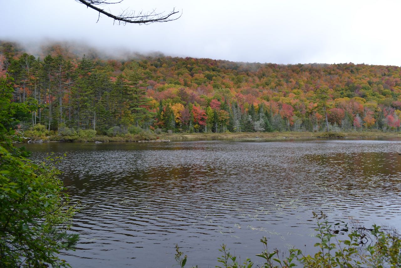
Three Ponds is the name of a chain of small waterbodies located in a hidden hollow that could almost be another wilderness area of the White Mountains. Though a modest hike in from the road, the trio (three by clever counting) has all the atmosphere of a deep, secluded wild. The ponds are nestled betwixt the high, curling mountain ridges of Carr Mountain and Mt. Kineo and the small Black Hill, just north of Stinson Lake. The trail network in this region forms a convenient loop that is regarded by fishermen and campers as well as day hikers. Among the most scenery-dense pond treks in the White Mountains, the loop hits in addition to the ponds beautiful open wetlands with mountain vistas, and bouldery streams with powerful cascades. Only two of the nominal "Three Ponds" are visited by the trail, but another pond is passed on the return leg of the loop, nearly as naturally vibrant as the two. One of this hike's most appealing prospects is fall foliage. Bright colors in the tree are enhanced well by the reflective water. And picnicking, especially at the upper pond's prime sitting rock, is a great allure.
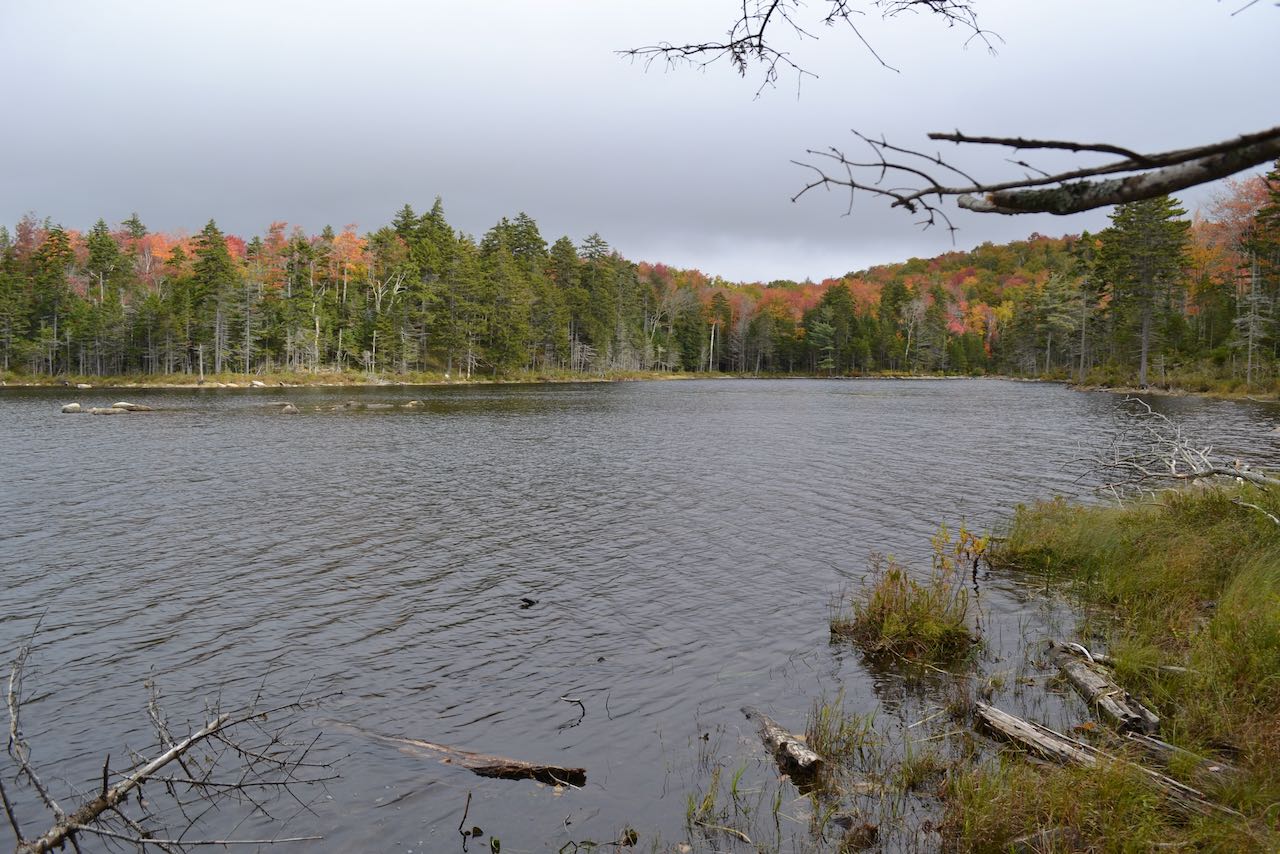
From the parking lot kiosk, follow the trail into the woods and arrive at a junction after just 0.1 miles. Keep straight at the signpost, as your return route comes in from the right. The wide track, shared with snowmobiles, rises easily for a bit, then levels off and meanders through hobblebush-dominated forest to pass another junction, this time with Carr Mountain Trail, in another 0.4 miles. Continue straight on Three Ponds Trail. Cutting across level ground, the path leads past a small swamp and in 0.35 miles approaches a scenic open area of grasses and gravel in Sucker Brook, the outlet waterway of the Three Ponds, just through the woods on the trail's left. In 0.15 miles, the trail crosses a sturdy snowmachine bridge over this brook, and makes a right turn on the opposite side, following close beside this wild, boulder-tossed mountain stream. In 0.3 miles, the trail bears right off the wide corridor and follows a newer footpath beside the water, passing a series of little cascades through blocky ledges in the brookbed. After 0.2 miles on the footpath, the trail passes a sluggish region in the brook exiting a marsh and rejoins the snowmobile route. Two branches of the brook converge into the marsh; the trail crosses both of them in succession over 0.15 miles. The trail stays close to the main Sucker Brook for the next 0.3 miles, then swings right as the snowmobile trail hops up a little hill - follow the snowmobile arrow. In 0.1 miles, Three Ponds Trail takes a left turn downhill off of the snowmobile trail. Watch carefully for this junction, marked with a yellow blaze and orange sign. Intrepid pond explorers will want to adventure 200 feet through the woods on the right side of the snowmobile trail around this junction, where the Lower Three Pond sits up on a small shelf, rimmed with a boggy fringe. No official trail was cut to access this sight, but the circular tarn is worth the small effort to see.
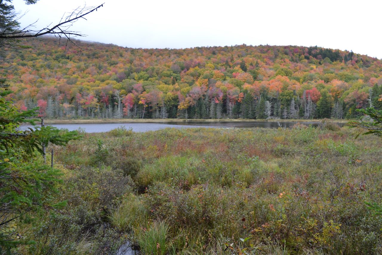
Continue on the main trail, soon turning right at a sign to stay on the path. The trail meanders through the woods and comes out into an opening at the south end of Middle Three Pond after 0.2 miles. Gorgeous views of the serene expanse are had from here and many points further along the shore. The pleasantly rolling hillsides form an artistic backdrop for the open waters, especially if they are alight with autumn hues. The trail hugs the east shore for a quarter mile, almost its whole length, tunneling through vegetation and passing several outlooks over the water, with increasing views of the towering slopes of Carr Mountain on the left side of the pond. Near the beginning of this section, a loop trail leads out to a camp shelter up on the hill. At the northern end of the pond, the trail skirts along a boggy section and arrives at a trail junction. To visit Upper Three Pond, you must continue straight on Three Ponds Trail as it here crosses Sucker Brook. The condition of this crossing may vary, as it is built over a beaver dam, and may range from moderately tricky to a swamp ford. Just be aware that visiting the upper pond from this side may not be possible at all times. If you can't make it over the brook, more scenic delights still await on the back half of the loop. If you can make it across, keep going on the trail as it meanders over a hump at the far north end of the middle pond where you can see back over the water. The trail is narrower and less used on this side, slicing through stands of hobblebush. In 0.2 miles, an unmarked spur path bears right and descends to the south shore of Upper Three Pond. One great sitting rock surveys the mild horseshoe shape of the waterbody. Deciduous forest with great fall foliage viewing potential blankets a hill on the left side, while conifers dominant the point in the middle and right side of the pond.
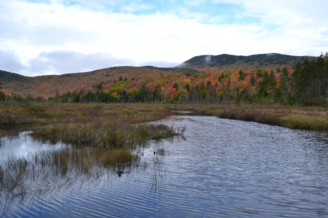
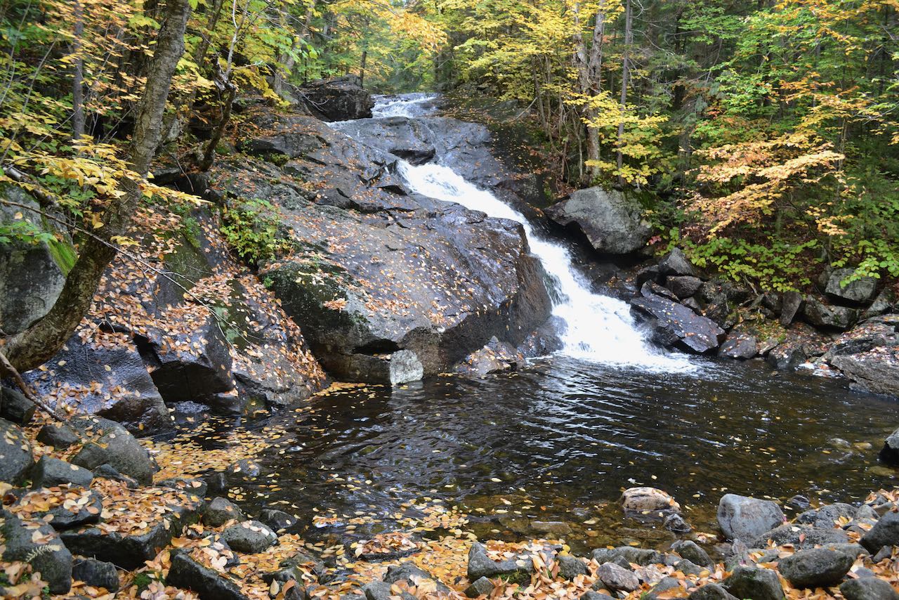
Beyond the upper pond, the trail continues toward its alternate trailhead (a much longer walk), passing Foxglove Pond, another mostly off-trail destination for dedicated explorers, after a half mile. To continue the loop, head back the way you came across the brook to the junction, and follow Donkey Hill Cutoff to your left (on the right, if you didn't cross the brook). The path slides alongside a boggy area draining out from the upper pond, with more scenic views and a few bog bridges, for a quarter mile before heading into the woods to climb over a small rise with a towering tree canopy. The trail reaches the edge of another, even more extensive boggy area in another quarter mile, where a faint path leads down to the edge. A view of the stately Mt. Kineo can be seen over the grasses and fir trees. The trail follows along the vast marshlands for 0.15 miles and comes out at an area of open water, where a beautiful view of Kineo and its surrounding hillsides is had. The trail swings around the outlet, and wanders through the woods for 0.3 miles to a trail junction at a snowmobile bridge over Brown Brook, which drains water to the east, eventually leading through the town of Ellsworth to reach the Pemigewasset River, whereas Sucker Brook drains south to Stinson Lake. Keep straight, now once again on a snowmobile trail, closely following the bouldery brook for 0.15 miles to where a side path accesses the bottom of a powerful cascade. The water crashes through a chute in a huge ledge into a stone-rimmed pool. The overwhelming scenery now concluded, the trail descends gently in proximity to the brook for the next half mile. The trail then turns right off the wide path at a sign and follows a narrow footpath across the slopes of Black Hill, which your loop has now completely encircled. The mellow path stays mostly on the level as it heads back toward the trailhead. It's a total of a mile back to the junction with Three Ponds Trail, at which point you can turn left and walk the 0.1 miles back to the trailhead.
Printable directions page